“Nash Harbor” refers to both the body of water and to the villages built at the mouth of the Ellikarrmiut River. “Ellikarrmiut” refers to the people who once lived here; in Cup’ig it means “People of the Sharpening Stone” (Griffin 1996). Two former villages are visible at Nash Harbor today. Area 1 lies on the east side of the Ellikarrmiut River; Mekoryuk residents commonly call this the “Old Village,” or Ellikarrmiut Village. Nowak’s (1988) investigations at the site found evidence for occupation here as early as AD 350. An epidemic—perhaps influenza—at Ellikarrmiut sometime around AD 1890 prompted the villagers to relocate across the river to the “New Village” or Qimugglugpaqmiut (“People of the Big Bad Dog”) (Griffin 1996), which I refer to as Area 2. Area 1 today is comprised of several deep (1 to 2 m), distinct house depressions, usually clustered into house complexes linked by common entrances. Tall beach grass (probably dune grass, Elymus mollis, Swarth 1934: 9), covers the surface of the site, partially or completely obscuring the structural features underneath.
Part of the Nash Harbor Village is located atop a long sandy spit projecting west across a broad lagoon formed by the Ellikarrmiut River (Figure 2.1). This spit nearly blocks the river, narrowing its outlet to about 5 meters. A grassy marsh has formed in the backwater behind the sand spit. Large subangular sand grains deposited in finely striated layers appear to comprise the basement material for Area 1. The tundra to the east of the site may have developed on rubble and igneous rock beach shingle eroding from Azwiryuk Bluff. On the beach exposure, these igneous rocks are rounded, flat stones 5 to 30 cm wide and 5 to 10 cm thick, well sorted by size and deposited in distinctly bedded planes interspersed with coarse beach sands. This suggests that the tundra east of Ellikarrmiut is formed on top of a series of shingle backbeaches (Bird 1984:112) similar to the beach east of the village today.
The spit underlying the village, however, seems to have formed entirely from sand deposited at the mouth of the Ellikarrmiut River by river sediments directed along shore by oblique longshore and offshore currents (Bird 1984:122–126). The finely-striated sands of the dune imply that the height of the dune derives mainly from the eolian redeposition of fine sands from the exposed beach. Dune grass stabilizes the terrace, especially the southward lee face (Bird 1984:176–179).
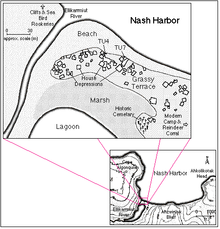
Figure 2.1, maps of 49-NI-003, Area 1, the “Old Nash Harbor Village,” and the lower
Nash Harbor area and Ellikarrmiut River valley. After Griffin 1996 and U.S.G.S. 7.5'
Series, Nunivak West A6.
1996 Archaeological Investigations at Nash Harbor
In the summer of 1996, I joined University of Oregon doctoral candidate Dennis Griffin and Oregon State University master’s student Chris Broyles in the archaeological exploration of Nash Harbor. Griffin also hired five Mekoryuk High School students through a grant from the Summer Youth Training Partnership Program (SYTPP). Griffin, Broyles, and I were jointly responsible for selecting units for excavation and overseeing the SYTPP workers’ screening, survey, and excavations. Broyles and I selected for excavation two shellfish and fishbone middens (TU4 and TU7, Figure 2.1) visible in the eroding beach bank. Griffin concentrated his efforts on the excavation of house floors, especially near the centers of houses where he thought he might find hearths. I also screened displaced slump material obscuring portions of a beach cutbank profile.
The field crew surveyed the Nash Harbor sites using an optical transit. An arbitrary metric grid was superimposed over the area; all units were laid in using coordinates of this grid. The field crew excavated test units in 10 cm arbitrary levels using trowels; slumps were cleared using shovels. The original excavation plan called for screening 3 quadrants of each 1 m square with 1/4" dry screen, and screening the remaining quadrant with 1/8" dry screen. Time and labor pressures forced us to abandon this strategy in favor of screening all material from a provenience with 1/4" screen, and retaining a two liter bulk sample from the general provenience. Additional bulk samples of midden materials were retained, as were discrete charcoal samples for 14C dating. Worked tools and other finished artifacts found during excavation were recorded and catalogued separately from the general screen sample, and recorded in situ where possible.
Excavators made a profile drawing of two walls from each finished test unit, and soil samples were retained from most strata exposed in profile. I also made a sketch map of the exposed beach cutbank in order to target midden areas that might prove useful for faunal recovery, and refined my sketch profiles in two areas of the beach to help fix stratigraphic sequences for nearby test units. Soils were mapped with a methodology that favored identification of buried surfaces and depositional episodes (Stein 1990). I designated proposed major depositional sequences with Roman numerals; substrata that may represent single depositional episodes within the stratum are designated with Arabic numerals. Therefore, Stratum III-1 indicates the first identified substratum in major Stratum III. Conjectured soil types and horizons were noted using basic soil science terminology (Holliday and Goldberg 1992).
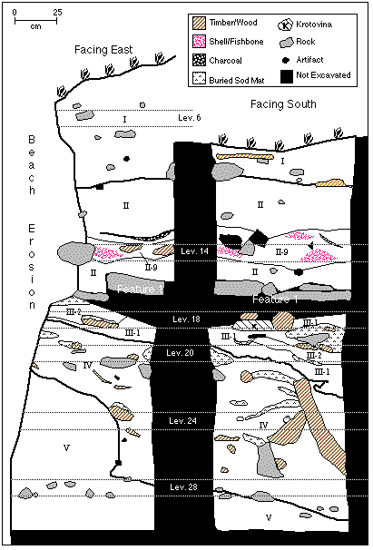
Figure 2.2, Stratigraphic profile map of Test Unit 4, south and east walls. Faunal
samples were taken from indicated levels. Most minor substrata omitted for clarity.
My own work concentrated on the study of faunal materials from two midden areas at the old village site, NH1. Preliminary stratigraphic profiles made on the eroded beach face identified several discrete midden areas that yielded abundant faunal material for study. I identified two midden deposits for excavation and laid out test units in each.
Test Unit 4 (TU4) is located just outside an entryway to a large house complex. Extensive deposits of fish, bird, and mammal bone were eroding from the bank in this area, and several large flat rocks and wooden timbers suggested that the unit might also contain buried structural members. Excavation of TU4 began at the top of the beach exposure. At around 50 cm below surface, we encountered soil frozen too hard to excavate and were forced to abandon work in the unit. We opened a second test unit (TU5) immediately south of TU4, hoping to stagger excavation of TU4 and TU5 to allow the soil to thaw. The rates of thaw proved too slow, however, so I concentrated my excavations in the north half of TU4, which had thawed about 50 cm back from the edge of the bank.
Around 160 cm below surface, the excavation crew encountered several large, flat rocks stacked two to three deep. None of these large rocks showed evidence of having been grinding stones or hearth stones; at the time, we conjectured that they may have been “flagstones” lining the floor of a food cache or sauna. This collection of rocks was dubbed “Feature 1,” and divided the excavation of TU4 into two vertical sections, top and bottom. Several of the stones proved too large to remove without damaging the excavation unit walls, and were left in situ with a thick pedestal underneath. Permafrost, Feature 1, and the depth of the unit conspired to make TU4 somewhat less than ideal in shape (Figure 2.2).
I proposed a division of the cultural sequence reflected in TU4 into at least 3 distinct episodes. Griffin and I speculated that the large upright timbers and mats of sod and moss present in Stratum IV signified the remains of a structure. The structure was eventually abandoned and collapsed, and subsequently covered by a layer of sand (Substratum III-1) and some cultural debris (Substratum III-2), which may have been associated with the construction in the second episode of Feature 1. In the third episode, people probably living in a nearby house complex heaped trash on top of Feature 1 (Stratum II).
Excavation of TU4 below 240 cm below surface partially exposed the anterior occipital margin of a large walrus skull, protruding from the west wall into the unit. After excavation of the unit, Broyles and I removed this skull and some surrounding soil. Two holes had been drilled in the nasal/maxillary region of the walrus skull, and the tusks removed by tapping on a dowel or wedge inserted through the drilled holes. As a byproduct of sample unit selection (see Section 3, below) this skull and some other walrus remains from Test Unit 4 are not included in the sample of analyzed faunal material.
Test Unit 7 (TU7) was located some 15 meters east of TU4. It sat about four meters east of an opening to a small house complex that was truncated by beach erosion. TU7 was probably associated with this feature or with a house that has eroded entirely into the sea. Structural members visible in the bank about eight meters east of the midden may have been all that remain of this conjectured dwelling.
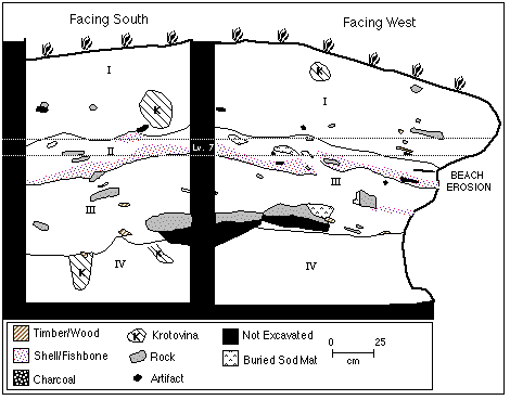
Figure 2.3, Stratigraphic profile map of Test Unit 7, south and west walls. Faunal
samples were taken from indicated levels. Most minor substrata omitted for clarity.
TU7 proved relatively shallow and free of permafrost. A lens of mussel and clam shell and some fishbone was visible from the beach; sketch profiles and slump clearing revealed a single intact midden deposit that we hoped would prove fruitful for faunal research. Like TU4, TU7 has an irregular shape due to the contour of the beach cutbank; the unit was extended in the northwest corner to reach the edge of the bank (Figure 2.3). Otherwise, excavation of the unit proved unexceptional.
The stratigraphy of TU7 probably represents no more than two occupational episodes. In the first episode (Stratum III), Ellikarrmiut people probably performed some outdoor activity, probably shellfish or plant processing, directly on beach sands. Alternately, the area may have been a lightly-used trash area, not an activity site. The conjectured break between Substrata III-1 and III-2 may represent a brief hiatus of activity. In the second episode, Ellikarrmiut people deposited shellfish debris (Stratum II). Although a stable surface may bound the top of Stratum III, very little time may have elapsed between the deposition of Stratum III and Stratum II materials.
Radiocarbon Dates from Test Units 4 & 7
The excavation crew recovered several wood charcoal samples from most strata. All samples were taken from single objects (to avoid averaging results from several samples throughout an excavation unit), and sealed in plastic bags for shipping to Oregon. Dennis Griffin cleaned and dried samples for shipping to Beta-Analytic laboratories. I calibrated calendar dates using Beta Analytic’s calibrations, and the University of Washington’s CALIB computer program; both calibration methods use the 1993 Pretoria calibration curve for short-lived samples (Gillespie 1986; Stuiver, et al., 1993; Vogel, et al., 1993). I calculated all statistical tests using CALIB and Michael Miller's Probability Calculator program. Figure 2.4 summarizes the range of calibrated calendar dates from the TU4 and TU7 midden deposits.
Radiocarbon-dating results from the Test Unit 4, Level 16 sample (above Feature 1) yielded a conventional radiocarbon age of 340 +/- 80 R.Y.B.P. Owing to multiple intercepts with the calibration curve, calibration at the 2 sigma level yielded three ranges calendar dates: AD 1425 to 1675, AD 1770 to 1800, and AD 1940 to 1950. Calibration at the 1 sigma level generated a more narrow range of possible dates, AD 1455 to 1655. Results from TU4, Level 25 yielded a conventional radiocarbon age 370 +/- 40 R.Y.B.P.; at 2 sigma this represents calendar dates of AD 1445 to 1645 (2 sigma), and AD 1460 to 1525 and AD 1560 to 1630 (1 sigma). The close probable ages of these two samples suggested that these units are statistically identical. Two-tailed t-distribution and chi-square testing showed these samples to be the same at the 95% level (T' = .11; X2(.05) = 3.84). I then computed pooled average dates for the TU4 samples, yielding a radiocarbon age of 364 +/- 36, with calibrated calendar ages of AD 1446 to 1644 (2 sigma), and AD 1471 to 1526 and AD 1556 to 1632 (2 sigma).
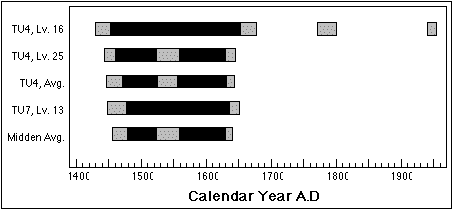
Figure 2.4: Calibrated radiocarbon to calendar dates for samples from TU 4 and TU7
middens. Dark bars indicate 1 sigma calibrated results; light bars indicate 2 sigma
calibrated results. Average for TU 4 was computed from weighted mean dates for level
16 and level 25 samples. Average for all midden samples was computed from weighted mean
dates for TU 4, levels 16 and 25, and TU 7, level 13.
Only one sample obtained from TU7 has been radiocarbon-dated. A single piece of wood charcoal from the boundary of Stratum III and Stratum IV yielded a conventional age of 350 +/- 40 R.Y.B.P., or calibrated calendar dates of AD 1450 to 1650 (2 sigma) and AD 1475 to 1640 (1 sigma). Since this date was derived from the boundary between anthropic soils and the sterile basement sands, it represented a lower boundary for the entire unit, not a date from the midden deposits per se. Considering the rapidity with which a meter of debris accumulated in TU4 (between levels 25 and 16), and a lack of historic Euroamerican artifacts in TU7, I think it probable that the radiocarbon date derived from TU7 represents the age of the entire test unit.
I tested the TU7 sample with the TU4 samples for statistical similarity, again finding them to be statistically the same at the 95% level (T' = .18; X2(.05) = 5.99). Confident that the radiocarbon dates all derive from the same statistical population, I calculated a pooled mean date for both midden deposits at a radiocarbon age of 358 +/- 27 BP. This yielded calibrated calendar dates of AD 1479 to 1525 and AD 1559 to 1631 (1 sigma), and AD 1456 to 1640 (2 sigma). With three dates from several different horizontal and vertical proveniences, I can confidently conclude that both midden deposits represent nearly contemporaneous events, between AD 1456 and AD 1640. Faunal analysis from the two midden deposits therefore provides a picture of Ellikarrmiut economic life around AD 1550.